ciao
fatta la "famosa" prova ecco la tabella che riassume il risultato:
<table cellpadding="0" cellspacing="0" width="406" border="0"><colgroup><col style="mso-width-source:userset;mso-width-alt:5668;width:116pt" width="155"> <col style="mso-width-source:userset;mso-width-alt:4534;width:93pt" width="124"> <col style="mso-width-source:userset;mso-width-alt:4644;width:95pt" width="127"> </colgroup><tbody><tr style="height:12.75pt" height="17"> <td class="xl24" style="height:12.75pt;width:116pt" height="17" width="155">
</td> <td class="xl24" style="width:93pt" width="124">Ascesa accumulata</td> <td class="xl24" style="width:95pt" width="127">Discesa accumulata</td> </tr> <tr style="height:12.75pt" height="17"> <td class="xl24" style="height:12.75pt" height="17">
</td> <td class="xl24">
</td> <td class="xl24">
</td> </tr> <tr style="height:12.75pt" height="17"> <td class="xl24" style="height:12.75pt" height="17">60csx</td> <td class="xl24">463</td> <td class="xl24">478</td> </tr> <tr style="height:12.75pt" height="17"> <td class="xl24" style="height:12.75pt" height="17">62s</td> <td class="xl24">409</td> <td class="xl24">422</td> </tr> <tr style="height:12.75pt" height="17"> <td class="xl24" style="height:12.75pt" height="17">traccia 62s (dati da compegps)
</td> <td class="xl24">461</td> <td class="xl24">435</td> </tr> </tbody></table>
mah!
Come si vede il l'ascesa accumulata del 60csx coincide quasi con quella calcolata da Compegps usando la traccia (ma la discesa no! )
)
Il dislivello massimo è stato di 440 mt.
Ciò conferma il comportamento strano dell'altimetro del 62s con la release 4.30 del firmware!
(Naturalmente l'altimetro dei due GPS era impostato allo stesso modo così come la calibrazione, il metodo e l'intervallo di rilevazione punti.)
grazie e ciao
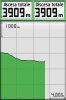
fatta la "famosa" prova ecco la tabella che riassume il risultato:
<table cellpadding="0" cellspacing="0" width="406" border="0"><colgroup><col style="mso-width-source:userset;mso-width-alt:5668;width:116pt" width="155"> <col style="mso-width-source:userset;mso-width-alt:4534;width:93pt" width="124"> <col style="mso-width-source:userset;mso-width-alt:4644;width:95pt" width="127"> </colgroup><tbody><tr style="height:12.75pt" height="17"> <td class="xl24" style="height:12.75pt;width:116pt" height="17" width="155">
</td> <td class="xl24" style="width:93pt" width="124">Ascesa accumulata</td> <td class="xl24" style="width:95pt" width="127">Discesa accumulata</td> </tr> <tr style="height:12.75pt" height="17"> <td class="xl24" style="height:12.75pt" height="17">
</td> <td class="xl24">
</td> <td class="xl24">
</td> </tr> <tr style="height:12.75pt" height="17"> <td class="xl24" style="height:12.75pt" height="17">60csx</td> <td class="xl24">463</td> <td class="xl24">478</td> </tr> <tr style="height:12.75pt" height="17"> <td class="xl24" style="height:12.75pt" height="17">62s</td> <td class="xl24">409</td> <td class="xl24">422</td> </tr> <tr style="height:12.75pt" height="17"> <td class="xl24" style="height:12.75pt" height="17">traccia 62s (dati da compegps)
</td> <td class="xl24">461</td> <td class="xl24">435</td> </tr> </tbody></table>
mah!
Come si vede il l'ascesa accumulata del 60csx coincide quasi con quella calcolata da Compegps usando la traccia (ma la discesa no!
)Il dislivello massimo è stato di 440 mt.
Ciò conferma il comportamento strano dell'altimetro del 62s con la release 4.30 del firmware!
(Naturalmente l'altimetro dei due GPS era impostato allo stesso modo così come la calibrazione, il metodo e l'intervallo di rilevazione punti.)
grazie e ciao