Garmin BaseCamp

pappamolle

Biker tremendus
29/12/08
1.112
1
0
Visita sito
Nella schermata che hai postato stai visualizzando solo la OpenMtbMap con le curve di livello,cioè openmtbmapsrtm_ita_ anzichè la vera e propria mappa openmapitalygg/mm/aaaa, in parole povere hai istallato sul Pc solo le curve di livello, ora disistallale con l'unistall, oppure eliminando il file dalla cartella dove lo hai istallato.
Poi scaricati la openmtbitalia da qui [url]http://openmtbmap.org/it/download/[/URL] .
Quando lanci l'istallazione istalla assieme le curve di livello selezionandole nell'apposita finestra che ti comparirà, e che ti chiederà l'istallazione simultanea.Perdonami se non sono stato abbastanza chiaro.

Se non mi sbaglio,nell'installazione,ho optato per le curve di livello separate perchè pensavo di avere una mappa in più.Magari riprovo ad disinstallare tutto e quando mi chiede di installare separato scelgo di no.
Comunque,le scarico le mappe,proprio dall'indirizzo che mi dici.

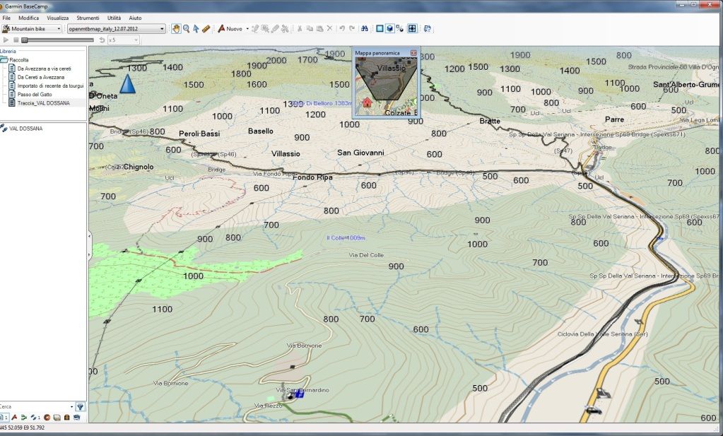
...in ogni caso le mappe le vedrai così

image.php


...per vederle così

image.php


...devono contenere i dem e le openmtbmap non li hanno...o-o...

Mai viste in questo modo le mappe,magari!..quelle che visualizzavo prima,erano precisamente come l'allegato che ho inviato nell'altro post,solo che le linee non erano disposte in modo piatto ma rialzate come i promontori,non so se mi spiego..
 

pappamolle

Biker tremendus
29/12/08
1.112
1
0
Visita sito
Ho installato in questo modo:
attachment.php

ho una mappa in meno(quella delle sole linee di livello) e continuo a non vedere com'era prima,non capisco boh.. :nunsacci:
Prima,riuscivo a visualizzare un qualcosa di simile:
3402256338_bcdbf1d1ab.jpg
 

Allegati

  • Senza titolo-2.jpg
    Senza titolo-2.jpg
    36,7 KB · Visite: 162

manuel73

Biker superis
16/5/08
359
7
0
Vertova- Bergamo
Visita sito
Bike
Genius LT700 TUNED
Controlla di aver selezionato Openmtbitaly_gg.mm.aaaa altrimenti selezionalo nell'apposita finestrella posta nella barra in alto di BaseCamp3.3.3
Il modo che hai selezionato per l'istallazione è corretto, però prima devi eliminare l'istallazione precedente delle sole curve di livello... ti ricordi dove le evevi istallate?????

Il mio screenshot..... ecco cosa devi vedere...
http://i783.photobucket.com/albums/yy119/Falket73/screenshot1.jpg
 

pappamolle

Biker tremendus
29/12/08
1.112
1
0
Visita sito
Si,seleziono proprio la mappa che dici tu,tanto di diverso ho solo "mappa globale" e niente più.
La disinstallazione lo fatta semplicemente andando in menù start di win-openstreetmap-uninstall.
Dici che devo farla "manualmente"?

Grazie
 

morsi

Biker ciceronis
19/5/08
1.544
-10
0
52
Bergamo
Visita sito
Bike
Cancello in ferro battuto
Domanda come mai BaseCamp su portatile ha la possibilità del 3D? scheda video?
 

Allegati

  • Immagine3D.jpg
    Immagine3D.jpg
    20,5 KB · Visite: 18
L

LAcek

Ospite
...andranno a ruba...o-o...già girate su basecamp e trasformate in .jnx per il mio garmino...o-o..
Ho provato a caricare delle mappe .jnx sul mio edge 800.
Le ho inserite nella cartella "custom map" ma non le vede (le kmz invece le vede perfettamente).
Cosa ho sbagliato?
 
L

LAcek

Ospite

scratera

Biker nirvanensus
30/6/07
26.176
2.376
0
rovereto TN
Visita sito
Bike
...
...nuova versione disponibile...stò ancora cercando di capire tutte le nuove possibilità implementate...tra cui condividere online le nostre tracce in un data base esterno.....:il-saggi:......e altro ancora.....:omertà:
 

Slimer

Biker forumensus
21/1/07
2.209
5
0
52
Milano
Visita sito
Bike
La Piera elettrica
.stò ancora cercando di capire tutte le nuove possibilità implementate..

In effetti c'è molta carne al fuoco in questa versione

  • Added Garmin Adventures, including; authoring, publishing, online search, downloading, playback, and transfer to supporting devices.
  • Added arrival, departure, and layover times for route via-points.
  • Added a context menu on the map for the hand and selection tools.
  • Added support for waypoint creation date, which will not be changed when updating the waypoint.
  • Added a list in the waypoint properties dialog to display which routes a waypoint is used in.
  • Added ability to collapse folder groups (like 'My Collection' or 'Devices').
  • Added support for temperature and pressure in track statistics and graphs.
  • Added support to delete waypoints that are included in a route.
  • Added Basestation mode for compatible Astro, Rhino, and Alpha devices.
  • Added more columns to the data view for Waypoints, Garmin Custom Maps, GeoCaches and Photos.
  • Added support to enter position using alternate grid/datum on the "Recenter Map To" dialog.
  • Added option to save original track when filtering it.
  • Added display of the "placed on" date for GeoCaches.
  • Added intersection search when using the "and" or "&" keywords.
  • Added ability to bulk-edit more fields for waypoints.
  • Added ability to create waypoint from find results on the map.
  • Added ability to transfer subscription-based BirdsEye imagery that contain failed downloads.
  • Added ability to toggle the visibility of all toolbars.
  • Added display of postal code in address search results.
  • Added a read-only 'Unlisted Data' list that contains all items that are in no other lists.
  • Added ability to create a route from a named trail.
  • Added ability to import into folders and lists (and not always import into My Collection).
  • Added header for the folder data list.
  • Added ability to duplicate geotagged photos.
  • Added link the BaseCamp license agreement in help menu.
  • Added ability to undo/redo on supported devices.
  • Added ability to drag and drop folders from the file system to BaseCamp (when supported data is present).
  • Added ability to accept Google Maps coordinate format when centering map at position.
  • Added new dog icons.
  • Added waypoint creation date to the waypoint properties dialog.
  • Added option to encourage the user to recalculate a route when the map that the route was created with isn't found on the device.
  • Added prompt when duplicating a route if BaseCamp should also duplicate the waypoints used in the route.
  • Added zooming via Alt/+ Alt/- keys. This is a coarse zoom which zooms in or out a number of zoom levels.
  • Added toolbar and menu for simpler device transfer options.
  • Improved display when many photos are at the same spot on the map.
  • Improved XML processing (so it should now be possible to import and export larger gpx files than previously).
  • Improved the measurement tool's display of measurement information.
  • Improved behavior when importing data into an already selected list or folder.
  • Improved behavior when double-clicking on a list. BaseCamp will now zoom to the data contained in that list.
  • Improved default file name for backup. The default name now contains the current date.
  • Improved the validation of map coordinates in the Recenter dialog.
  • Changed the simple route dialog to transition into the route properties so the route can be edited further.
  • Changed icon for gas stations with convenience stores to be the gas station icon, not the shopping cart.
  • Clarified the find options (Center of view, Center of selected items). Added hint text to make usage more clear.
  • Cleaned up toolbar, hide tools that are used less often by default, always show waypoint, route & track tools.
  • Cleaned up route options, made it easier to create custom route settings.
  • Fixed the long find toolbar initialization delay after starting BaseCamp or switching to a new map.
  • Fixed an issue where a device's SD card would not always be recognized by BaseCamp.
  • Fixed numerous issues with finding addresses.
  • Fixed an issue where the toolbar would not display the same way after restarting BaseCamp.
  • Fixed an issue where the find toolbar would always be displayed after restarting BaseCamp, even though the user chose to hide it.
  • Fixed area calculation for tracks.
  • Fixed an issue where you could not rename an item from lower case to upper case (like renaming "washington" to "Washington").
  • Fixed issue where the Geocache symbol was not consistent with found status when importing or adding a geocache.
  • Fixed an issue where the preferences dialog would not remember the last sub-selection.
  • Fixed an issue with remembering the data filters when switching between app modes.
  • Fixed an issue where turning off the display of points would leave a lot of "shopping cart" POIs on the map for certain map products.
  • Fixed an issue where the selection was lost when left-clicking on the map with the hand tool.
  • Fixed issues with route/track creation and joining.
  • Fixed issues with deleting data on devices.
  • Fixed issues with creating routes from tracks.
  • Fixed issue when BirsdEye selection box was dragged too far North.
  • Fixed issue with displaying custom maps on devices.
  • Fixed various issues with the route properties dialog.
 

manuel73

Biker superis
16/5/08
359
7
0
Vertova- Bergamo
Visita sito
Bike
Genius LT700 TUNED
In 3D con OpenStreetMap non si notano le pendenze create dalle curve di livello, credo che con altre mappe si possano vedere ma io non sò con quali.
Questo è lo screenshoot della visualizzazione 3D che vedo io... spero sia simile alla tua.


Screenshoot2.jpg
 

pappamolle

Biker tremendus
29/12/08
1.112
1
0
Visita sito
In 3D con OpenStreetMap non si notano le pendenze create dalle curve di livello, credo che con altre mappe si possano vedere ma io non sò con quali.
Questo è lo screenshoot della visualizzazione 3D che vedo io... spero sia simile alla tua.


Screenshoot2.jpg

Le vedevo semplicemente in questo modo..c'era un minimo effetto 3D..
3402256338_bcdbf1d1ab.jpg
 

Classifica giornaliera dislivello positivo

Classifica mensile dislivello positivo