E' disponibile la versione 1.13.2
Questi sono gli ultimi changelog
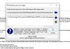
Per chi avesse compilato manualmente su linux e volesse aggiornare la procedura è la seguente:
Questi sono gli ultimi changelog
V 1.13.2
[Issue #446] Advanced Filtering System
[Issue #491] Skip saving of geo search
[Issue #493] "Clone Waypoint and Move Clone" does not Respect Chosen Units
[Issue #488] Printing Preview
[Issue #494] BRouter segments download error
[Issue #499] Screen overflow German localisation on a Notebook with 1.600 x 900 pixel
[Issue #500] Tab order in Filter Cycle dialog is confused
[Issue #498 ] BRouter setup issue (Windows)
Add: Computation of "Energy Use Cycling" (consumption) for cycling tours
V 1.13.1
[Issue #451] Make red border around a highlighted track an option
[Issue #452] Project Details: Add elevation info to entries with track point information.
[Issue #455] Profile Plot: Add option to show waypoint labels along line
[Issue #456] Clean up code regarding track info, attached wpt and hidden flag.
[Issue #460] Missing "Change Map View Name" action in toolbar
[Issue #465] Garmin IMG: Extend Tooltip
[Issue #467] Add activity color to track info and graph
[Issue #469] Reduce width of track detail dialog
[Issue #470] Crash when saving geocache
[Issue #471] Fix background color of textboxes and bubble for dark color themes
[Issue #477] BRouter setup issue (Windows)
[Issue #479] Unnecessary extra tag(s) when saving GPX file
[Issue #480] Graph not appearing when activating it
[Issue #481] Project Details: Add a roadbook with progress graphs
[Issue #466] Geocache detecting duplicates
[Issue #266] Scale on printed maps
[Issue #484] MainWindow slope display does not honor slope unit setting
[Issue #394] Added slope row in ruler table
Trk: Increase desity of arrows for tracks with a high track point frequency
BSD Fix: do not access QStringList.first() if list is empty
V 1.13.0
[Issue #298] Live GPS data
[Issue #430] Add waypoint summary to project details
[Issue #436] Route history is buggy and causes data loss when auto-routing is enabled
[Issue #433] Suppress ascent/descent if wrong
[Issue #438] Partially: Support for PROJ 6.0.0
[Issue #429] Add Geocaching Attributes
[Issue #434] Mega-fancy tour description on screen
[Issue #448] Project Details: Add track points with additional information to lists
[Issue #443] Garmin Map: Fixing elevation marks
[Issue #450] Waypoint: copy coordinate to clipboard
Per chi avesse compilato manualmente su linux e volesse aggiornare la procedura è la seguente:
Codice:
cd ~/GPS/QMapShack
hg pull
hg update
cd ../build_QMapShack
make
sudo make install